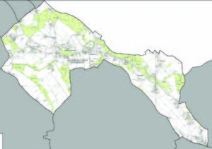
Cholesbury-cum-St Leonards parish lies to the north-west of Chesham and close to the highest point in the Chiltern Hills in Buckinghamshire. It is bounded on its eastern edge by the county boundary with Hertfordshire, and to the north by Grims Ditch. The parish was created in April 1934 through bringing together four small hilltop communities previously part of other parishes. Since then the parish has increased in size through the annexing of small parcels of land from neighbouring parishes.
Cholesbury-cum-St Leonards Parish Area
(Click on image to enlarge)
The parish comprises the four villages of Buckland Common, Cholesbury, Hawridge and St Leonards as well as the outlying hamlets of The Vale, Heath End, Lanes End and part of Braziers End. At the time of the 2011 census the population was 956 and there were 382 households. There is a Primary School – Hawridge and Cholesbury (CofE) School, two village halls and three pubs, though currently only two are trading. There are no shops and buses run once each way on just four days of the week.
The whole area is criss-crossed by small lanes, footpaths and bridleways and is popular with those who enjoy cycling, horseriding or walking, and visiting local sites such as Cholesbury Camp (Iron-Age Hillfort), the three churches (St Marys Hawridge, St Leonards and St Lawrence, Cholesbury) or the Commons at Hawridge and Cholesbury or Buckland Common.
